Author's Note: This piece first appeared at Daily Kos on August 19, 2011, as an entry in the site's "Stop Tar Sands" Blogathon. It is reposted here with minor edits as part of my Scars Upon Sacred Land series. Data and dates refer, of course, to the situation as it stood in 2011, but not much has changed, and indeed, the final public comment period is about to close this Friday night.
I opened the first in my series, Scars Upon Sacred Land, this way:
There is a reason why we refer to the earth as our mother.Many — perhaps most — of our traditional stories and lessons are tied inextricably to the land. Historical, humorous, educational, cautionary; stories of earth and air, fire and water, plants and animals and every living thing; our history, our languages, our cultural and political and spiritual traditions all are bound up with Akii, our Mother Earth, and her children.
The land lives; it is animated by Spirit. It sustains us: physically, spiritually. We are the land, and it is us - and any injury to it injures us all.
And so is our future.
If, that is, we actually have a future.
If the North American tar sands projects are allowed to go forward, the possibility of any future - for the entire planet - is gravely in doubt.
But for the indigenous peoples of Turtle Island, it is genocide.
When I was a child, my father used to tell me the old stories and lessons of the Anishinaabeg. No matter how far I wandered from my roots, one that remained with me is found in various versions among Native peoples the continent over, expressed as our responsibility to the future, "even unto the seventh generation."
Nowhere is this more true than with regard to our stewardship of Akii.
Ironically, the colonizers brought their own version of a seventh generation prophecy - flipped, inverted, a mirror image of ours. Where ours focused on doing good for those who come after us, the colonizers' version, predictably, obsessed over the bad: "visiting the iniquity of the fathers upon the children unto the third and fourth generation."
Looking at the arc of North American history over the last 500 years, the colonizers clearly won that contest. Granted, it was a self-fulfilling prophecy on their part, but now, half a millennium later, no less true for all that. Whatever good the modern inhabitants of Turtle Island may have done with regard to our environment is, at the moment, far outweighed by the damage inflicted, and we're well past the tipping point. It's no longer a prevention operation, but emergency rescue, recovery, and rehabilitation.
But if we permit tar sands operations to continue and expand, we adopt the colonial vision of the prophecy: We curse the future, unto the seventh generation and far beyond, and we are accursed ourselves, for enabling such wanton destruction of Akii, of her sand and soil and waters, of her plants and medicines, or her finned and winged and four-, six-, and eight-legged children — and of her two-legged ones, those who come after us, and who will surely suffer and die for our lack of action now.
Here's why.
WHAT ARE TAR SANDS?
Tar sands, also known as oil sands, are more properly called bituminous sands. They comprise a toxic stew of heavy crude oil, silica (sands), clay, and bitumen, otherwise known as asphalt. Bitumen is a highly viscous byproduct of crude oil — black, sticky. Earlier generations called it pitch, and for millennia, and Native peoples used it to to waterproof canoes and other items. In other words, it's what the average layperson calls tar.
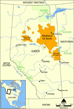
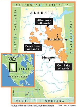
The world's single largest deposit of tar sands, the Athabasca Oil Sands, is in Alberta, Canada. Alberta also contains two somewhat smaller deposits, Peace River and Cold Lake. (The three deposits are shown in yellow on the map below.) Taken together, the three tar sands cover a land mass of some 140,000 square kilometers, roughly the size of New York State, and constitute the second-largest oil deposit in the world (exceeded only by the oil deposits of Saudi Arabia).
However, unlike crude oil found in ordinary deposits, the oil in tar sands is not in immediately-useable form. The bitumen must first be extracted from the sands; it then undergoes a refining process to turn it into crude oil. These processes are expensive and resource-intensive, and available methods are currently limited to strip mining, open-pit mining, or a complex process involving underground heating. After extraction, the bitumen must undergo both "upgrading"' and dilution. Even so, some two tons' worth of tar sands are necessary to produce one barrel of crude oil.
Open-pit mining, which caries its own serious environmental risks, is only feasible for tar sands deposits that are relatively near the surface. Deeper deposits are accessible only via deep injections of steam and.or solvents, otherwise known as fracking, and are also extraordinarily dangerous to the environment.
The process carries other dangers, too. Turning tar sands into crude oil generates three times the greenhouse gas emissions of ordinary oil production. It requires a tremendous expenditure of freshwater, in increasingly short supply in these days of global climate change: anywhere from three to six barrels of water are needed to create one barrel of crude oil from tar sands, while production of that one barrel generates another barrel and a half of toxic waste — which is then stored in toxic tailings ponds that leach into the local watershed. And mining and extraction require clear-cutting of the surface area to clear what the industry terms the "overburden." In Alberta, that "overburden" comprises one of the continent's largest boreal forests.
THE KEYSTONE XL PIPELINE PROPOSAL
The proposed Keystone XL Pipeline is a project of TransCanada Corporation. There are two primary TransCanada divisions: the Pipelines division, which comprises both oil and natural gas; and the "Energy" division, which encompasses everything else — coal, hydro, natural gas, nuclear power, wind, and such subdivisions as gas storage, power generation, and market trading of electricity. With operations throughout Canada, the U.S., and Mexico, TransCanada's pipelines already transect North America. However, mindawe generally knows no bounds, and so it is with TransCanada, whose 2010 net income alone exceeded $1.2 billion.
Here's how TransCanada describes the Keystone XL Pipeline Project:
The U.S. $13 billion Keystone pipeline system will play an important role in linking a secure and growing supply of Canadian crude oil with the largest refining markets in the United States, significantly improving North American security supply.What you may not know is that TransCanada already runs a tar sands pipeline across a significant section of the U.S. Phase I of the pipeline project, begun in June, 2010, converted an existing natural gas pipeline system to one designed to carry crude oil, transporting it nonstop from Hardisty, Alberta, to Steele City, Nebraska, and points east — specifically, Wood River and Patoka, Illinois - by way of a so-called "bullet line." Phase II, which went live in February, 2011, extended the bullet line southward from Steele City to Cushing, Oklahoma - right in the very heart of Indian Country. Phase I is represented by the solid dark red lines, and Phase II by the solid orange line, on TransCanada's map, below:
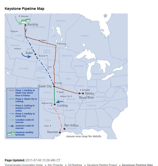
Phases III and IV, which the company calls the Gulf Coast Expansion Project [GCEP], is the portion of the pipeline project for which TransCanada currently seeks U.S. approval. (Phases III and IV are represented by the broken orange and dark blue lines on the map above.) But the planned GCEP is not merely an expansion of the existing pipeline; it involves construction of an entirely new, 1,661-mile tar sands pipeline. The new line is slated to run from Hardisty, Alberta, through the southwest corner of Saskatchewan and across the U.S. border, thence diagonally across Montana, South Dakota, and Nebraska, to the Steele City-to-Cushing segment. At Cushing, new construction would extend southward across eastern Texas to two termini: one in Port Arthur and one in Beaumont, both on the coast of the Gulf of Mexico. The pipe itself, 36 inches in diameter, is expected to transport between a half million and a million barrels of crude oil per day from Canada to the U.S.
In its application for U.S. approval, TransCanada touted its own safety analysis, which predicted "only" 11 major spills (defined as 50 or more barrels of crude oil per spill) over the life of the pipeline's operation. John Stansbury, a University of Nebraska water resources engineer who conducted an independent assessment, alleges that TransCanada grossly underestimated the likely number of spills. According to Mr. Stansbury, the pipeline is likely to average some 91 major spills, a dozen of which are likely to occur via holes of ten or more inches. He also alleges that TransCanada significantly underestimated the volume of oil that would be released in a given spill, basing its estimates on the mistaken assumption that any spill would be discovered immediately. And since the proposed pipeline will transect at least 11 major river crossings, such spills could contaminate the Ogallala Aquifer, a major Great Plains watershed, the Missouri and Mississippi Rivers, and the Yellowstone River with such deadly toxins as benzene. At least two small leaks are already known to have occurred in the existing portions of the new Keystone XL pipeline. And in May, a scant ten months since the first phase of the Keystone XL pipeline went live, 500 barrels of crude oil leaked into one of the company's substations in South Dakota, spraying crude onto adjacent land. The May leak came a week after a 28,000-barrel spill from a Plains All American pipeline in northern Alberta.
IMPACTS ON CANADIAN TRIBAL LANDS
The tar sands' negative impacts on tribal lands is already well-documented in Canada — and tribal opposition is aggressive and well-organized. The Indigenous Environmental Network (IEN) is a leader in the fight to stop not only the Keystone XL pipeline, but what IEN correctly terms the Tar Sands Gigaproject, "the largest industrial project on Mother Earth." In the Tar Sands Gigaproject, TransCanada is only one of nearly 30 different multinational corporate players currently casting industrial lots for Akii's garments in Alberta.
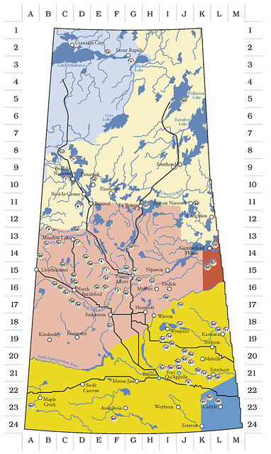
It's impossible for any tar sands operation in Canada to function without affecting tribal lands. Compare the map of Alberta's tar sands, immediately below:
with this map of Alberta's tribal lands:
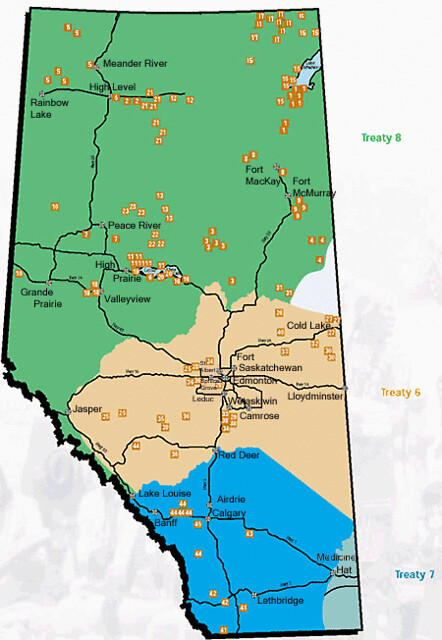
Not only do the deposits sit on or adjacent to numerous First Nations Reserves (and their watersheds), but the pipelines and effects of mining and extraction clearly transgress lands protected by federal treaties. If the pipeline expansion is approved, it will do the same to tribal lands in southwestern Saskatchewan:
But the treaty violations are esoteric compared to the acute physical damage the tar sands projects are inflicting upon Canada's First Nations. According to IEN:
Currently, tar sands operations are licensed to divert 652 million cubic meters of fresh water each year, 80% from the Athabasca River. In comparison, this amounts to approximately 7 times the annual water needs of the city of Edmonton. About 1.8 million cubic metres of this water becomes highly toxic tailings waste each day.
In 2008, tar sands operations produced 37.2 megatonnes of greenhouse gas emissions, an increase of 121% between 1990 and 2008. Planned tar sands growth indicates a near tripling of emissions between 2008 and 2020, to a projected 108 megatonnes.
In 2006, unexpectedly high rate of rare cancers were reported in the community of Fort Chipewyan. In 2008, Alberta Health confirmed a 30% rise in the number of cancers between 1995 -2006. However, the study lacks appropriate data and is considered a conservative estimate by many residents.
Caribou populations have been severely impacted by tar sands extraction. The Beaver Lake Cree First Nation has experienced a 74% decline of the Cold Lake herd since 1998 and a 71% decline of the Athabasca River herd since 1996. Today, just 175 - 275 caribou remain. By 2025, the total population is expected to be less than 50 and locally extinct by 2040.In recent years, other studies have found that local moose populations have dangerously elevated arsenic levels, while fish and other traditional food sources show high levels of mercury and exposure to arsenic and polycyclic aromatic hydrocarbons (known carcinogens). Beginning in 2003, Ft. Chipewyan physician John O'Connor reported unusually high incidences of various cancers:
He documented a number of cases of cholangiocarcinoma, a rare cancer of the bile duct that typically affects only one in 100,000 people. He reviewed the health histories of the town's residents and saw a high incidence of colorectal cancer and an abnormally high number of gastrointestinal cancers.The cancer rates were so ridiculously high that he began publicly questioning whether contamination from the tar sands operations were to blame. Canadian health officials subsequently filed a formal professional complaint against Dr. O'Connor, accusing him of "raising undue alarm"; he was eventually cleared of the charge. NoDirtyEnergy.org maintains a list of links to studies and reports on environmental and human-health impacts of Canada's tar sands operations.
IMPACTS ON U.S. TRIBAL LANDS
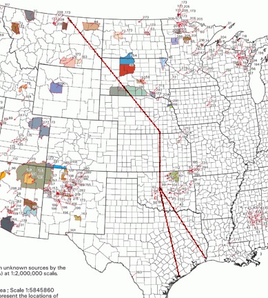
Despite the fact that miles of tar sands pipeline already traverse substantial portions of the United States, and despite ongoing attempts to mine tar sands deposits in the U.S., there has been far less documentation of local impacts on U.S. tribes. That such impacts would be substantial, however, is clear from a quick glance at the following map. The various colored and shaded blocks represent reservation lands; the red lines roughly trace the path of TransCanada's proposed new Keystone XL pipeline project. The proposed pipeline cuts a path across six states, each with tribal lands. In some cases, the pipeline will run near enough to such lands to endanger them in event of a spill; in others, the pipeline will go directly through tribal lands, and a spill will do much more than merely endanger them.
But the pipeline need not cross, or even abut, tribal lands to inflict terrible damage. A spill in the Ogallala Aquifer has the potential to contaminate the watersheds of eight states: South Dakota, Wyoming, Nebraska, Colorado, Kansas, Oklahoma, Texas, and New Mexico. And that's only the most obvious watershed risk. As Anthony Swift of the NRDC reports:
TransCanada is assuring Montanans that the Keystone XL pipeline would be buried deep under rivers and streams in Montana and in other places along its route. Keystone XL would cross 1,904 rivers, streams and reservoirs along its route. TransCanada plans to use horizontal directional drilling, a method of constructing a pipeline twenty or more feet below a riverbed, for thirty-nine of these rivers. At the 1,865 other river, stream and reservoir crossings, TransCanada would build Keystone XL a mere five feet below the riverbed.That's nearly 2,000 separate water crossings, many of which serve the tribes not only in the six states the pipeline will cross, but in adjacent and downstream states, as well.
"A SLOW INDUSTRIAL GENOCIDE"
In its report on tar sands operations, IEN notes:
Environmental racism is a reality of Canadian development projects and with tar sands in particular. In 2001, 1,200 First Nation communities lived within 200 km of mining operations nationally. Further, the Assembly of First Nations reported (2001) that 36% of all First Nation communities lived within 50 km of mining developments and associated pollution zones. This number has grown substantially over the past decade creating disproportionate impact and higher health risks as compared to the general population. Permitting and environmental assessment processes in Canada fail to recognize accumulative affects and lack of indicators that assess cultural and spiritual impacts for First Nation communities. The Alberta tar sands developments have been fast-tracked through the weak regulatory process and have had inadequate consultation with First Nations leadership and communities. Rather, the Alberta and Canadian government rely on junk science put forth by industry and ignore the real concerns and well-being of First Nation peoples. As such, the battle over the tar sands mining comes down to the fundamental right to exist as Indigenous peoples. The tar sands are a human rights issue.Think about that for a moment: "the fundamental right to exist." For indigenous peoples, that is what is at stake here. As IEN makes clear, the Canadian government has no right to grant permits for any activity on unceded (i.e., sovereign) First Nations territories, but it does so regularly, in defiance of the U.N. Declaration on the Rights of Indigenous Peoples (UNDRIP). Canada became an UNDRIP signatory last year, but it qualified its signing with a formal objection to UNDRIP's requirement that indigenous peoples be afforded the right of "Free, Prior and Informed Consent" (FPIC) with regard to issues that affect sovereignty — such as development.
Historically, energy and mining interests have exploited the economic poverty of the Reserve system to induce tribes to agree to permit mining, drilling, and extraction operations on their lands. This is not a new approach, nor is it confined to Canada: Such interests routinely attempt to lure U.S. tribes into making similar deals with the devil. Today, however, a number of Canadian tribes have begun to fight back, asserting their sovereignty via a combination of lawsuits, organizing, civil disobedience, and direct action.
In BC, 61 First Nations signed a resolution in December, 2010 to oppose the Enbridge Northern Gateway pipeline. Building on this resolution, in Feburary2011 the Yinka Dene Alliance rejected an offer from Enbridge for "revenue sharing" benefits representing more than $1.5-billion in cash, jobs, business opportunities during the next 30 years, as well as a 10% stake in the project stating that water, land and cultural heritage were more important than short-term financial gain. Similarly, in August of 2010, the indigenous hereditary chiefs of the Wet'suwet'en First Nation issue[d] a final notice of trespassing to Enbridge, stating the company was no longer welcome on their territory. Since then, community members have constructed a traditional long house directly in the path of the proposed pipeline and are resolute that pipelines will not cross their territory.For more than 500 years, the indigenous peoples of Turtle Island have been battling organized and systemic attempts at genocide. Whether via religious conversion at the end of a spear or a noose; deliberate introduction of smallpox and alcohol; wholesale slaughter pursuant to an invading government's "Indian policy"; extermination of the buffalo and other resources; theft of sacred lands and internment in concentration camps; attempted annihilation of language, culture, and identity; forced sterilization; or, now, human and environmental destruction at the hands of corporate and industrial interests, we are still here.
And we have a responsibility. Even unto the seventh generation.
Please support the efforts of the Indigenous Environmental Network and the Native Network Organizations. Please support the upcoming protests at the White House. If you can attend, please do; if not, please write, call, or e-mail the White House and urge that TransCanada's application be denied. And if you can kick in a few bucks, please do that, too. Because preventing more scars upon sacred land helps ensure future generations' survival — for all of us.
Copyright Ajijaakwe, 2011, 2014; all rights reserved.

No comments :
Post a Comment